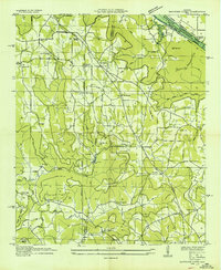
1936 Map of Newsome Sinks
USGS Topo · Published 1936About this map
Newsome Sinks characterizes the karst topography of this corner of Marshall County, where the Tennessee Valley Authority was actively reshaping the landscape in the mid-1930s. The northern edge of the sheet shows the creation of Wheeler Reservoir, with the Wheeler Reservoir Boundary cutting through the river bottoms near Clarksville Landing. This era was one of significant transition, as the Nashville Chattanooga and St Louis Railroad Ferry operated along the original river channel before rising waters altered local transport.
Find a feature on this map
48 named features on this map. Tap any name to fly to it.
Don’t see what you’re looking for? This feature index may not catch every label — zoom into the map to look around manually.
Map Details
Editions of this 1936 Newsome Sinks Map
This is the sole edition of this map. No revisions or reprints were ever made.
Other maps of this area

1885 · Gadsden
USGS Topo · 1:125,000

1888 · Cullman
USGS Topo · 1:125,000

1888 · Gadsden
USGS Topo · 1:125,000

1888 · Scottsboro
USGS Topo · 1:125,000

1888 · Huntsville
USGS Topo · 1:125,000

1892 · Cullman
USGS Topo · 1:125,000

1892 · Huntsville
USGS Topo · 1:125,000

1892 · Scottsboro
USGS Topo · 1:125,000

1892 · Gadsden
USGS Topo · 1:125,000

1895 · Gadsden
USGS Topo · 1:125,000