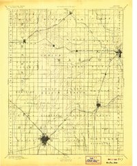
1894 Map of Newton
USGS Topo · Published 1906About this map
Newton serves as the primary rail hub on this late 19th-century survey, anchoring a landscape defined by the arrival of major transit lines across Harvey and Marion counties. The Atchison Topeka and Santa Fe Railroad (McPherson Br.) and the Chicago Rock Island and Pacific Railroad create a structural grid that dictated the placement of grain-trading towns like Peabody, Lehigh, and Walton. Beyond the iron rails, the drainage patterns of Emma Creek and the South Cottonwood River illustrate the natural topography that early settlers navigated before the complete division of the land into townships. Notable smaller settlements, including Aulne, Canada, and Durham, appear in their early configurations, providing a clear record of the region's development during the peak of the railroad era.
Find a feature on this map
69 named features on this map. Tap any name to fly to it.
Don’t see what you’re looking for? This feature index may not catch every label — zoom into the map to look around manually.
Map Details
Editions of this 1894 Newton Map
5 editions found

Other maps of this area

1888 · Eldorado
USGS Topo · 1:125,000

1889 · Newton
USGS Topo · 1:125,000

1889 · Abilene
USGS Topo · 1:125,000

1889 · Parkerville
USGS Topo · 1:125,000

1889 · Cheney
USGS Topo · 1:125,000

1889 · Wichita
USGS Topo · 1:125,000

1891 · Hutchinson
USGS Topo · 1:125,000

1891 · Cheney
USGS Topo · 1:125,000

1892 · Salina
USGS Topo · 1:125,000

1893 · Hutchinson
USGS Topo · 1:125,000