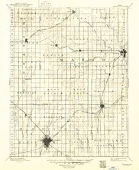
1894 Map of Newton
USGS Topo · Published 1949About this map
The Newton townsite anchors the southwestern corner of this survey, serving as a vital rail hub where multiple lines converge. The central Kansas landscape is defined by its early rail-and-river economy, with the Cottonwood River and South Cottonwood River carving paths through the eastern townships of Risley and Marion. The settlement pattern follows the tracks of the Atchison Topeka and Santa Fe Railroad and the Chicago Rock Island and Pacific Railroad, which facilitated the growth of rural communities like Peabody, Hillsboro, and Lehigh. Beyond the grid-like township divisions, the terrain rises at Battle Hill and is drained by an intricate system of prairie waterways, including Emma Creek and Doyle Creek. The 1888 reconnaissance work highlights a period of established farming and transit before the turn of the century, providing a clear view of the county boundaries between McPherson, Marion, Harvey, and Butler counties.
Find a feature on this map
74 named features on this map. Tap any name to fly to it.
Don’t see what you’re looking for? This feature index may not catch every label — zoom into the map to look around manually.
Map Details
Editions of this 1894 Newton Map
5 editions found

Other maps of this area

1888 · Eldorado
USGS Topo · 1:125,000

1889 · Newton
USGS Topo · 1:125,000

1889 · Abilene
USGS Topo · 1:125,000

1889 · Parkerville
USGS Topo · 1:125,000

1889 · Cheney
USGS Topo · 1:125,000

1889 · Wichita
USGS Topo · 1:125,000

1891 · Hutchinson
USGS Topo · 1:125,000

1891 · Cheney
USGS Topo · 1:125,000

1892 · Salina
USGS Topo · 1:125,000

1893 · Hutchinson
USGS Topo · 1:125,000