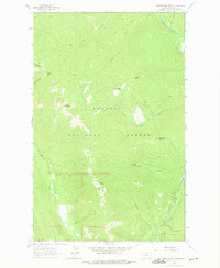
1963 Map of Newton Mountain
USGS Topo · Published 1975About this map
The Yaak River flows through this 1963 survey of the northern Panhandle, where the landscape is defined by the high ridges of the Kootenai National Forest. Resource extraction and navigation are evident in the presence of the Black Diamond Mine and a small Mine near the riverbank. The terrain is marked by prominent peaks such as Newton Mountain, Abe Lincoln Mountain, and Keystone Mountain, which are connected by a network of Pack Trails.
Find a feature on this map
25 named features on this map. Tap any name to fly to it.
Don’t see what you’re looking for? This feature index may not catch every label — zoom into the map to look around manually.
Map Details
Editions of this 1963 Newton Mountain Map
3 editions found
Other maps of this area

1911 · Priest Lake
USGS Topo · 1:250,000

1913 · Priest Lake
USGS Topo · 1:250,000

1957 · Kalispell
USGS Topo · 1:250,000

1958 · Sandpoint
USGS Topo · 1:250,000

1960 · Kalispell
USGS Topo · 1:250,000

1961 · Kalispell
USGS Topo · 1:250,000

1963 · Sandpoint
USGS Topo · 1:250,000

1963 · Sylvanite
USGS Topo · 1:24,000

1963 · Mount Baldy
USGS Topo · 1:24,000

1963 · Pulpit Mountain
USGS Topo · 1:24,000