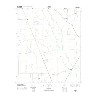
2011 Map of Neyami
USGS Topo · Published 2011About this map
Starksville and the surrounding agricultural landscape of Lee County are defined by the intricate winding paths of Muckalee Creek and Muckaloochee Creek in this 2011 survey. The map records a series of established rural settlements and family-named landmarks, including Scrutchins, Neyami, and the Jordan Place, illustrating the persistent footprint of local landholdings. To the north, the Henderson Cemetery serves as a vital point for genealogical research, while water features like Eagle Pond and King Lake suggest a terrain punctuated by natural and man-made basins. The road network, including Old Stage Rd and Old Leslie Rd, indicates long-traveled routes that have connected these communities for generations. This survey provides a clear view of the intersection between the natural drainage of the Boggy Branch and Fox Creek systems and the structured parcels of Georgia's coastal plain.
Find a feature on this map
34 named features on this map. Tap any name to fly to it.
Don’t see what you’re looking for? This feature index may not catch every label — zoom into the map to look around manually.
Map Details
Editions of this 2011 Neyami Map
This is the sole edition of this map. No revisions or reprints were ever made.
Other maps of this area

1953 · Dothan
USGS Topo · 1:250,000

1954 · Dothan
USGS Topo · 1:250,000

1955 · Dothan
USGS Topo · 1:250,000

1956 · Sasser
USGS Topo · 1:62,500

1956 · Albany
USGS Topo · 1:62,500

1956 · Leslie
USGS Topo · 1:62,500

1973 · Sasser
USGS Topo · 1:24,000
1973 · Bronwood
USGS Topo · 1:24,000
1973 · Albany NE
USGS Topo · 1:24,000
1973 · Neyami
USGS Topo · 1:24,000