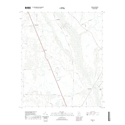
2020 Map of Neyami
USGS Topo · Published 2020About this map
Starksville and the surrounding agricultural lands of Lee County are defined by an intricate network of waterways and rural corridors. The landscape is dominated by the broad, meandering paths of Muckalee Creek and Muckaloochee Cr, which create complex drainage patterns across the terrain. Small settlements like Neyami and Scrutchins anchor the road system, while local history is preserved at the Henderson Cem near Boggy Branch.
Find a feature on this map
41 named features on this map. Tap any name to fly to it.
Don’t see what you’re looking for? This feature index may not catch every label — zoom into the map to look around manually.
Map Details
Editions of this 2020 Neyami Map
This is the sole edition of this map. No revisions or reprints were ever made.
Other maps of this area

1953 · Dothan
USGS Topo · 1:250,000

1954 · Dothan
USGS Topo · 1:250,000

1955 · Dothan
USGS Topo · 1:250,000

1956 · Sasser
USGS Topo · 1:62,500

1956 · Albany
USGS Topo · 1:62,500

1956 · Leslie
USGS Topo · 1:62,500

1973 · Sasser
USGS Topo · 1:24,000
1973 · Bronwood
USGS Topo · 1:24,000
1973 · Albany NE
USGS Topo · 1:24,000
1973 · Neyami
USGS Topo · 1:24,000