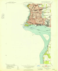
1949 Map of Niagara Falls
USGS Topo · Published 1949About this map
The Niagara Falls urban corridor and the surging waters of the Niagara River dominate this 1940s landscape, captured just before the massive post-war expansion of the local hydroelectric infrastructure. The map details the intricate cluster of islands above the precipice, including Goat Island and the Three Sisters Islands, while documenting the precise locations of the American Falls and Horseshoe Falls. Beyond the tourist vistas, the city's residential and industrial grid is densely packed with neighborhood landmarks like Trott Vocational Sch and St Marys Hospital. To the south, the Chippawa Channel separates the mainland from Grand Island, where the rural character is marked by the Staly Cem and small farm roads. The presence of the Erie RR and NYC RR lines underscores the city's role as a vital mid-century transportation and industrial hub.
Find a feature on this map
72 named features on this map. Tap any name to fly to it.
Don’t see what you’re looking for? This feature index may not catch every label — zoom into the map to look around manually.
Map Details
Editions of this 1949 Niagara Falls Map
This is the sole edition of this map. No revisions or reprints were ever made.
Other maps of this area

1894 · Buffalo
USGS Topo · 1:62,500

1894 · Niagara Falls
USGS Topo · 1:62,500

1896 · Niagara Falls
USGS Topo · 1:62,500

1897 · Tonawanda
USGS Topo · 1:62,500

1899 · Niagara
USGS Topo · 1:125,000

1900 · Tonawanda
USGS Topo · 1:62,500

1900 · Niagara Falls
USGS Topo · 1:62,500

1901 · Buffalo
USGS Topo · 1:62,500

1901 · Niagara Falls
USGS Topo · 1:62,500

1901 · Tonawanda
USGS Topo · 1:62,500