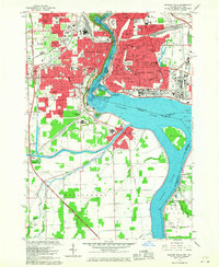
1965 Map of Niagara Falls
USGS Topo · Published 1968About this map
Niagara River cascades over the American Falls, Bridal Veil Falls, and the massive Horseshoe Falls, defining the international boundary and the industrial character of this mid-1960s landscape. This survey captures the urban density of Niagara Falls alongside the developing suburban communities of Stamford Centre and Queensway Gardens. The map details a complex transport and power infrastructure, including the Canadian National and New York Central railroads, as well as several intake systems and power plants serving the region's energy needs. Educational and social foundations are deeply mapped, from Gaskill High Sch and Trott Vocational Sch to the Armory and City Hall. Further south, the terrain transitions into the lowlands near the Welland River and Chippawa Channel, where Navy Island and Grand Island sit in the wider reach of the river before it narrows toward the gorge.
Find a feature on this map
80 named features on this map. Tap any name to fly to it.
Don’t see what you’re looking for? This feature index may not catch every label — zoom into the map to look around manually.
Map Details
Editions of this 1965 Niagara Falls Map
This is the sole edition of this map. No revisions or reprints were ever made.
Other maps of this area

1894 · Buffalo
USGS Topo · 1:62,500

1894 · Niagara Falls
USGS Topo · 1:62,500

1896 · Niagara Falls
USGS Topo · 1:62,500

1897 · Tonawanda
USGS Topo · 1:62,500

1899 · Niagara
USGS Topo · 1:125,000

1900 · Tonawanda
USGS Topo · 1:62,500

1900 · Niagara Falls
USGS Topo · 1:62,500

1901 · Buffalo
USGS Topo · 1:62,500

1901 · Niagara Falls
USGS Topo · 1:62,500

1901 · Tonawanda
USGS Topo · 1:62,500