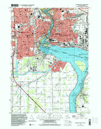
1995 Map of Niagara Falls
USGS Topo · Published 1999About this map
The borderlands of the Niagara River are documented here in detail, showcasing the massive industrial and hydraulic engineering that surrounds the natural wonder. The sheer scale of power generation is evident through the presence of the Sir Adam Beck Powerplant and the Ontario Powerplant, which flank the falls. On the Canadian side, established neighborhoods like Stamford Centre and Drummondville sit near the historic Lundys Lane, while the American city is densely packed with civic infrastructure, including Memorial Hospital and several neighborhood schools like Beech Ave Sch.
Find a feature on this map
73 named features on this map. Tap any name to fly to it.
Don’t see what you’re looking for? This feature index may not catch every label — zoom into the map to look around manually.
Map Details
Editions of this 1995 Niagara Falls Map
This is the sole edition of this map. No revisions or reprints were ever made.
Other maps of this area

1894 · Buffalo
USGS Topo · 1:62,500

1894 · Niagara Falls
USGS Topo · 1:62,500

1896 · Niagara Falls
USGS Topo · 1:62,500

1897 · Tonawanda
USGS Topo · 1:62,500

1899 · Niagara
USGS Topo · 1:125,000

1900 · Tonawanda
USGS Topo · 1:62,500

1900 · Niagara Falls
USGS Topo · 1:62,500

1901 · Buffalo
USGS Topo · 1:62,500

1901 · Niagara Falls
USGS Topo · 1:62,500

1901 · Tonawanda
USGS Topo · 1:62,500