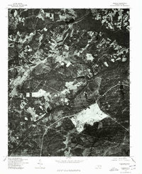
1976 Map of Niagara
USGS Topo · Published 1978About this map
Moore County's wooded landscapes and agricultural clearances are revealed in high detail through this orthophotoquad produced by the Soil Conservation Service and the Geological Survey. The dominant geographic marker is Lake Niagara, situated in the northern section of the map where the terrain begins to transition into more concentrated residential and commercial patterns. Because this is an orthophotograph rather than a traditional line-and-symbol map, it provides an unfiltered visual record of the 1970s land use, showing the specific layout of farmsteads, winding country roads, and the density of the surrounding pine forests before subsequent decades of development altered the rural character of this North Carolina region.
Find a feature on this map
1 named feature on this map. Tap any name to fly to it.
Don’t see what you’re looking for? This feature index may not catch every label — zoom into the map to look around manually.
Map Details
Editions of this 1976 Niagara Map
This is the sole edition of this map. No revisions or reprints were ever made.
Other maps of this area

1948 · Southern Pines
USGS Topo · 1:62,500

1948 · Clifdale
USGS Topo · 1:62,500

1948 · Pinebluff
USGS Topo · 1:24,000

1948 · Nicholson Creek
USGS Topo · 1:24,000

1948 · Mc Cain
USGS Topo · 1:24,000

1950 · Sanatorium
USGS Topo · 1:24,000

1950 · Lobelia
USGS Topo · 1:24,000

1950 · Pine Bluff
USGS Topo · 1:24,000

1950 · Niagara
USGS Topo · 1:24,000

1950 · Southern Pines
USGS Topo · 1:24,000