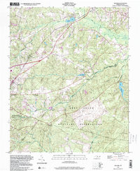
1998 Map of Niagara
USGS Topo · Published 2000About this map
Fort Bragg Military Reservation occupies a significant portion of this Moore and Hoke County landscape, where the northern perimeter of the base meets the sprawling sandhills ecosystem. This area is characterized by a network of drainage creeks including James Creek, Mc Deeds Creek, and Rockfish Creek, which feed into local water bodies like Crystal Lake and Lake MacArthur. The map documents a cluster of settlements along the rail corridor, from Vass and Lakeview in the north through Niagara and Skyline down to Southern Pines. Local institutional history is preserved through the locations of the Old Notre Dame Academy, Pleasant Hill Ch, and the Goins Cem. Conservation efforts are highlighted by the Weymouth Woods State Sandhills Nature Preserve, reflecting the region's commitment to protecting its unique longleaf pine environment amidst nearby military and residential expansion.
Find a feature on this map
35 named features on this map. Tap any name to fly to it.
Don’t see what you’re looking for? This feature index may not catch every label — zoom into the map to look around manually.
Map Details
Editions of this 1998 Niagara Map
This is the sole edition of this map. No revisions or reprints were ever made.
Other maps of this area

1948 · Southern Pines
USGS Topo · 1:62,500

1948 · Clifdale
USGS Topo · 1:62,500

1948 · Pinebluff
USGS Topo · 1:24,000

1948 · Nicholson Creek
USGS Topo · 1:24,000

1948 · Mc Cain
USGS Topo · 1:24,000

1950 · Sanatorium
USGS Topo · 1:24,000

1950 · Lobelia
USGS Topo · 1:24,000

1950 · Pine Bluff
USGS Topo · 1:24,000

1950 · Niagara
USGS Topo · 1:24,000

1950 · Southern Pines
USGS Topo · 1:24,000