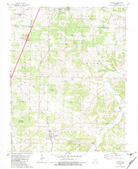
1982 Map of Niangua
USGS Topo · Published 1983About this map
Niangua and Conway anchor this 1980s landscape at the boundary of Webster, Laclede, and Dallas counties. The Burlington Northern railroad serves as a primary north-south corridor, connecting these settlements through the undulating terrain of the Missouri Ozarks. Large tracts of the Niangua State Forest dominate the southern half of the sheet, preserving the woodland character around the Osage Fork and the Gasconade River.
Find a feature on this map
42 named features on this map. Tap any name to fly to it.
Don’t see what you’re looking for? This feature index may not catch every label — zoom into the map to look around manually.
Map Details
Editions of this 1982 Niangua Map
This is the sole edition of this map. No revisions or reprints were ever made.
Other maps of this area

1939 · Long Lane
USGS Topo · 1:62,500

1941 · Lebanon
USGS Topo · 1:62,500

1942 · Long Lane
USGS Topo · 1:62,500

1943 · Lebanon
USGS Topo · 1:62,500

1946 · Niangua
USGS Topo · 1:62,500

1948 · Niangua
USGS Topo · 1:62,500

1954 · Springfield
USGS Topo · 1:250,000

1956 · Duncan
USGS Topo · 1:24,000

1956 · Rader
USGS Topo · 1:24,000

1958 · Springfield
USGS Topo · 1:250,000