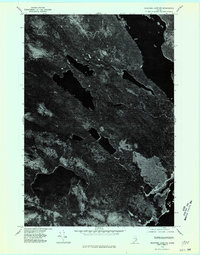
1975 Map of Nicatous Lake NE
USGS Topo · Published 1980About this map
Duck Lake occupies the southwestern portion of this 1975 orthophotoquad, which covers a remote stretch of the Maine interior. Unlike standard topographic maps, this aerial imagery reveals the actual density of the forest canopy and the complex shoreline of the lake itself. The sheet is exceptionally sparse, reflecting the undeveloped nature of the Hancock County landscape during the mid-1970s. For researchers and property historians, the contrast between the dark waters of Duck Lake and the varying textures of the surrounding timberland provides a visual record of forest management and natural topography that traditional line maps often simplify. The imagery was rectified from high-altitude photography to create an accurate cartographic representation of a region where named landmarks and human settlements are almost entirely absent.
Find a feature on this map
1 named feature on this map. Tap any name to fly to it.
Don’t see what you’re looking for? This feature index may not catch every label — zoom into the map to look around manually.
Map Details
Editions of this 1975 Nicatous Lake NE Map
This is the sole edition of this map. No revisions or reprints were ever made.
Other maps of this area

1931 · Springfield
USGS Topo · 1:48,000

1932 · Nicatous Lake
USGS Topo · 1:48,000

1934 · Nicatous Lake
USGS Topo · 1:62,500

1934 · Springfield
USGS Topo · 1:62,500

1941 · Scraggly Lake
USGS Topo · 1:62,500

1941 · Wabassus Lake
USGS Topo · 1:62,500

1943 · Wabassus Lake
USGS Topo · 1:62,500

1944 · Scraggly Lake
USGS Topo · 1:62,500

1953 · Wabassus Lake
USGS Topo · 1:62,500

1954 · Millinocket
USGS Topo · 1:250,000