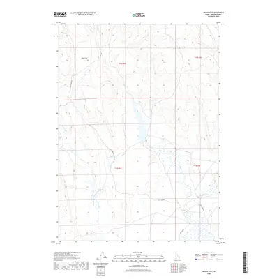
2020 Map of Nichol Flat
USGS Topo · Published 2020About this map
Nichol Flat and the surrounding high desert of Owyhee County are defined by a complex network of seasonal drainages and isolated water sources. This 2020 survey reveals a landscape where water is the primary landmark, featuring Blue Cr, Harris Cr, and Little Blue Cr weaving through the arid terrain. Natural springs like Rodeo Spring and Hawks Nest Spring serve as critical points of interest in an area otherwise dominated by expansive flats and subtle elevation changes. Human presence is marked primarily by foundational infrastructure, notably Battle Creek Rd and Point Lock Rd, which provide access through this remote portion of southern Idaho. The map captures the enduring character of the high plateau before the impact of more intensive modern development.
Find a feature on this map
12 named features on this map. Tap any name to fly to it.
Don’t see what you’re looking for? This feature index may not catch every label — zoom into the map to look around manually.
Map Details
Editions of this 2020 Nichol Flat Map
This is the sole edition of this map. No revisions or reprints were ever made.
Other maps of this area

1955 · Jordan Valley
USGS Topo · 1:250,000

1957 · Jordan Valley
USGS Topo · 1:250,000

1958 · Jordan Valley
USGS Topo · 1:250,000
1971 · Flying H Ranch
USGS Topo · 1:24,000
1971 · Riddle
USGS Topo · 1:24,000

1971 · Ross Lake
USGS Topo · 1:24,000

1972 · Wickahoney Point
USGS Topo · 1:24,000

1972 · Little Blue Table
USGS Topo · 1:24,000

1972 · Turner Table
USGS Topo · 1:24,000
1972 · Nichol Flat
USGS Topo · 1:24,000