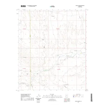
2023 Map of Nichols Canyon
USGS Topo · Published 2023About this map
The Gila River winds through the heart of this landscape, carving deep relief into the borderlands of Hidalgo and Grant counties. The dramatic topography is defined by the Gila Lower Box and the steep walls of Box Canyon, showcasing a classic Southwestern river corridor before it exits toward the high desert. Settlement evidence is sparse, represented by ranching infrastructure like Brown Ranch Rd and several water catchments including Mesa Tank and Tank Number Two. Numerous named drainages, such as Davenport Canyon and L C Canyon, feed into the river system from the surrounding highlands. Notable landmarks like Black Mountain and Redrock Mesa provide significant vertical context to the area, while Nichols Spring and Seep Spring Draw mark rare water sources in the arid terrain.
Find a feature on this map
32 named features on this map. Tap any name to fly to it.
Don’t see what you’re looking for? This feature index may not catch every label — zoom into the map to look around manually.
Map Details
Editions of this 2023 Nichols Canyon Map
This is the sole edition of this map. No revisions or reprints were ever made.
Other maps of this area

1954 · Silver City
USGS Topo · 1:250,000

1958 · Silver City
USGS Topo · 1:250,000

1959 · Steeple Rock
USGS Topo · 1:62,500

1959 · Redrock
USGS Topo · 1:62,500

1959 · Canador Peak
USGS Topo · 1:62,500

1959 · Cliff
USGS Topo · 1:62,500

1962 · Silver City
USGS Topo · 1:250,000
1990 · Willow Draw
USGS Topo · 1:24,000
1990 · Walker Canyon
USGS Topo · 1:24,000
1990 · Steeple Rock
USGS Topo · 1:24,000