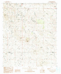
1990 Map of Steeple Rock
USGS Topo · Published 1991About this map
The Carlisle Mine and its neighboring Graves anchor a landscape defined by intensive resource extraction along the border of Grant and Hidalgo counties. This 1990 survey captures a rugged mining district where the terrain is heavily marked by Adits, Mine Shafts, and numerous Prospects. Named operations like the Golden Nugget Mine, Mount Royal Mine, and East Camp Mine are concentrated near the dramatic namesake Steeple Rock and Mount Royal. Beyond the industrial activity, the map records high-desert ranching infrastructure including the Hext Place, Upper Ranch, and Raeburn Windmill Corral. Natural water sources such as Summit Spring and Kelley Spring stand out as critical landmarks in a region of steep canyons like Laura Canyon and Cottonwood Canyon.
Find a feature on this map
71 named features on this map. Tap any name to fly to it.
Don’t see what you’re looking for? This feature index may not catch every label — zoom into the map to look around manually.
Map Details
Editions of this 1990 Steeple Rock Map
This is the sole edition of this map. No revisions or reprints were ever made.
Other maps of this area

1954 · Silver City
USGS Topo · 1:250,000

1958 · Silver City
USGS Topo · 1:250,000

1959 · Steeple Rock
USGS Topo · 1:62,500

1959 · Canador Peak
USGS Topo · 1:62,500

1959 · York Valley
USGS Topo · 1:62,500

1960 · Duncan
USGS Topo · 1:62,500

1962 · Silver City
USGS Topo · 1:250,000
1986 · Duncan
USGS Topo · 1:24,000
1986 · Tillie Hall Peak
USGS Topo · 1:24,000
1986 · Goat Camp Spring
USGS Topo · 1:24,000