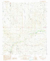
1990 Map of Nichols Canyon
USGS Topo · Published 1991About this map
Redrock Mesa and the winding course of the Gila River define this corner of the New Mexico landscape where the border between Hidalgo Co and Grant Co cuts through steep canyon country. The area reflects a history of small-scale extraction and ranching, evidenced by the presence of the Black Bob Mine, Wilson Mine, and Consolation Mine tucked into the ridges south of Deadman Ridge. Transportation and water management are key themes here, with the Trans Line crossing the rugged terrain while a Gaging Sta and Check Dam monitor the river's flow near the small Cem and local Landing Strip. The network of corrals and windmills, such as the Bar U Windmill Corral and Anderson Windmill, highlights the enduring importance of water sources like Nichols Spring for local stock raising in this arid environment.
Find a feature on this map
35 named features on this map. Tap any name to fly to it.
Don’t see what you’re looking for? This feature index may not catch every label — zoom into the map to look around manually.
Map Details
Editions of this 1990 Nichols Canyon Map
This is the sole edition of this map. No revisions or reprints were ever made.
Other maps of this area

1954 · Silver City
USGS Topo · 1:250,000

1958 · Silver City
USGS Topo · 1:250,000

1959 · Steeple Rock
USGS Topo · 1:62,500

1959 · Redrock
USGS Topo · 1:62,500

1959 · Canador Peak
USGS Topo · 1:62,500

1959 · Cliff
USGS Topo · 1:62,500

1962 · Silver City
USGS Topo · 1:250,000
1990 · Willow Draw
USGS Topo · 1:24,000
1990 · Walker Canyon
USGS Topo · 1:24,000
1990 · Steeple Rock
USGS Topo · 1:24,000