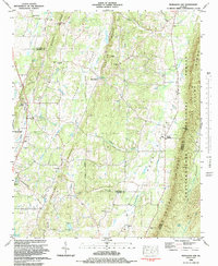
1983 Map of Nickajack Gap
USGS Topo · Published 1984About this map
Peavine Valley and the parallel ridges of Boynton Ridge and Peavine Ridge define the rural landscape of northwest Georgia in the early 1980s. This survey details a transition from traditional agriculture to a more connected corridor, with the Central of Georgia line running through the western reaches near the Walker County Area Technical School. The eastern portion is dominated by the steep ascent of Taylor Ridge, where the Chattahoochee National Forest provides a buffer against the valleys below. Numerous family and community landmarks such as McIntyre Cem and Wood Station offer concrete points of reference for local genealogy. Small congregational centers like Mt Pisgah Ch and Bethel Ch are scattered throughout the drainages of Peavine Creek and Little Chickamauga Creek, marking the enduring social nodes of this Catoosa and Walker County borderland.
Find a feature on this map
48 named features on this map. Tap any name to fly to it.
Don’t see what you’re looking for? This feature index may not catch every label — zoom into the map to look around manually.
Map Details
Editions of this 1983 Nickajack Gap Map
This is the sole edition of this map. No revisions or reprints were ever made.
Other maps of this area

1886 · Ringgold
USGS Topo · 1:125,000

1892 · Ringgold
USGS Topo · 1:125,000

1935 · Catlett
USGS Topo · 1:24,000

1935 · East Ridge
USGS Topo · 1:24,000

1935 · Villanow
USGS Topo · 1:24,000

1935 · Ringgold
USGS Topo · 1:24,000

1935 · Nickajack Gap
USGS Topo · 1:24,000

1935 · Tunnel Hill
USGS Topo · 1:24,000

1936 · Kensington
USGS Topo · 1:24,000

1936 · Estelle
USGS Topo · 1:24,000