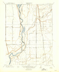
1910 Map of Nicolaus
USGS Topo · Published 1947About this map
The Feather River corridor in Sutter County defines this landscape, where early 20th-century agriculture and transportation converged at the junction of the Bear River. This survey captures the region just as the irrigation and rail infrastructure of the Sacramento Valley matured, centering on the historic town of Nicolaus. The map details the legacy of the massive New Helvetia and Johnson Rancho land grants, showing how these colonial-era boundaries influenced the modern grid of schools like Illinois School and gathering places such as Fairview Church. A dense network of rail lines, including the Southern Pacific R R and Northern Electric R R, served small shipping points and rail stops like Nicolaus Sta and Rio Oso, facilitating the movement of crops from the fertile bottomlands near Lake of the Woods and the O'Connor Lakes.
Find a feature on this map
27 named features on this map. Tap any name to fly to it.
Don’t see what you’re looking for? This feature index may not catch every label — zoom into the map to look around manually.
Map Details
Editions of this 1910 Nicolaus Map
2 editions found

Other maps of this area

1888 · Marysville
USGS Topo · 1:125,000

1888 · Smartsville
USGS Topo · 1:125,000

1891 · Sacramento
USGS Topo · 1:125,000

1891 · Marysville
USGS Topo · 1:125,000

1891 · Smartsville
USGS Topo · 1:125,000

1892 · Sacramento
USGS Topo · 1:125,000

1892 · Smartsville
USGS Topo · 1:125,000

1893 · Sacramento
USGS Topo · 1:125,000

1894 · Smartsville
USGS Topo · 1:125,000

1894 · Marysville
USGS Topo · 1:125,000