
1910 Map of Nicolaus
USGS Topo · Published 1910About this map
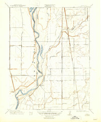
The confluence of the Feather River and Bear River dominates this early twentieth-century landscape in the Sacramento Valley. The map captures a moment when the region's transport network was rapidly evolving, showing the Northern Electric R R, the Western Pacific R R, and the Oroville Branch of the Southern Pacific R R cutting across the alluvial plains. Historical land grants like New Helvetia and the Johnson Rancho remain prominent markers of the area's Mexican land grant heritage. Small agricultural hubs and rail stops such as Nicolaus, Rio Oso, and Marcuse serve as focal points for local commerce, while community landmarks like Fairview Church and Illinois School provide vital evidence for genealogical research. The intricate network of waterways, including Ping Slough, Coon Creek, and Lake of the Woods, illustrates the natural drainage patterns before modern extensive levee and water management systems fully transformed the terrain.
Find a feature on this map
25 named features on this map. Tap any name to fly to it.
Don’t see what you’re looking for? This feature index may not catch every label — zoom into the map to look around manually.
Map Details
Editions of this 1910 Nicolaus Map
2 editions found
Other maps of this area

1888 · Marysville
USGS Topo · 1:125,000

1888 · Smartsville
USGS Topo · 1:125,000

1891 · Sacramento
USGS Topo · 1:125,000

1891 · Marysville
USGS Topo · 1:125,000

1891 · Smartsville
USGS Topo · 1:125,000

1892 · Sacramento
USGS Topo · 1:125,000

1892 · Smartsville
USGS Topo · 1:125,000

1893 · Sacramento
USGS Topo · 1:125,000

1894 · Smartsville
USGS Topo · 1:125,000

1894 · Marysville
USGS Topo · 1:125,000