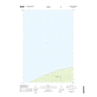
2019 Map of Nighthawk Creek
USGS Topo · Published 2019About this map
Lake Superior dominates the northern reaches of this coastal map, where the rugged shoreline of the Upper Peninsula meets the Great Lakes. The land rises steeply from the water into the Ottawa National Forest, a terrain defined by the drainage patterns of small coastal streams. This 2019 survey documents a sparsely populated corridor of Ironwood Township, where the transition from the lake to the interior is marked by the course of Nighthawk Cr and Ghost Cr. Human activity is minimal on this stretch of coast, centered largely around Jarvi Rd as it winds through the forest parallel to the shore. The map provides a clear look at the topographic relief and natural hydrology within the t49n r47w township boundary, capturing the intersection of public forest lands and the lakefront.
Find a feature on this map
6 named features on this map. Tap any name to fly to it.
Don’t see what you’re looking for? This feature index may not catch every label — zoom into the map to look around manually.
Map Details
Editions of this 2019 Nighthawk Creek Map
This is the sole edition of this map. No revisions or reprints were ever made.
Other maps of this area

1943 · Little Girls Point
USGS Topo · 1:24,000

1943 · Little Girl Point
USGS Topo · 1:48,000

1953 · Ashland
USGS Topo · 1:250,000

1956 · North Ironwood
USGS Topo · 1:62,500
1956 · Little Girls Point
USGS Topo · 1:62,500

1958 · Ashland
USGS Topo · 1:250,000
1980 · Little Girls Point
USGS Topo · 1:24,000
1980 · Black River Harbor
USGS Topo · 1:25,000
1989 · Ashland
USGS Topo · 1:100,000
1999 · North Ironwood
USGS Topo · 1:24,000