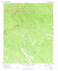
1971 Map of Nimblewill
USGS Topo · Published 1973About this map
Amicalola Mountain dominates this topographic survey of the north Georgia highlands, where the Chattahoochee National Forest covers a complex network of ridges and river headwaters. The settlement of Nimblewill and the smaller community at Afton serve as anchors for the local road network, which transitions into Jeep Trail and primitive footpaths as the elevation rises. Notable landmarks such as Springer Mtn and Cochrans Falls define the vertical landscape, while a Lookout Tower on Frosty Mtn provided a critical vantage point for forest management. For the genealogist and local historian, the map preserves the exact locations of rural religious life at Wesley Chapel and the New Hope Ch, alongside family-named terrain like Jake Mtn and Bearden Creek. The mapping of Amicalola Falls State Park shows the development of the area for public recreation, including Amicalola Lake and various designated picnic areas.
Find a feature on this map
41 named features on this map. Tap any name to fly to it.
Don’t see what you’re looking for? This feature index may not catch every label — zoom into the map to look around manually.
Map Details
Editions of this 1971 Nimblewill Map
4 editions found
Other maps of this area

1888 · Ellijay
USGS Topo · 1:125,000

1890 · Suwanee
USGS Topo · 1:125,000

1892 · Ellijay
USGS Topo · 1:125,000

1894 · Suwanee
USGS Topo · 1:125,000

1898 · Ellijay
USGS Topo · 1:125,000

1911 · Ellijay
USGS Topo · 1:125,000

1926 · Tate
USGS Topo · 1:62,500

1928 · Tate
USGS Topo · 1:62,500

1935 · Noontootla
USGS Topo · 1:24,000

1935 · Tickanetley
USGS Topo · 1:24,000