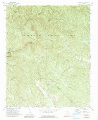
1971 Map of Nimblewill
USGS Topo · Published 1991About this map
Amicalola Falls State Park and the high ridges of the Chattahoochee National Forest dominate this 1971 survey of north Georgia. The map documents a landscape defined by significant elevation changes and water features, from the heights of Springer Mtn and Frosty Mtn down to the cascading Cochrans Falls. Within the mountainous terrain, isolated communities like Nimblewill are connected by a network of unimproved roads and jeep trails that follow the winding paths of Nimblewill Creek and Cochrans Creek.
Find a feature on this map
46 named features on this map. Tap any name to fly to it.
Don’t see what you’re looking for? This feature index may not catch every label — zoom into the map to look around manually.
Map Details
Editions of this 1971 Nimblewill Map
4 editions found
Other maps of this area

1888 · Ellijay
USGS Topo · 1:125,000

1890 · Suwanee
USGS Topo · 1:125,000

1892 · Ellijay
USGS Topo · 1:125,000

1894 · Suwanee
USGS Topo · 1:125,000

1898 · Ellijay
USGS Topo · 1:125,000

1911 · Ellijay
USGS Topo · 1:125,000

1926 · Tate
USGS Topo · 1:62,500

1928 · Tate
USGS Topo · 1:62,500

1935 · Noontootla
USGS Topo · 1:24,000

1935 · Tickanetley
USGS Topo · 1:24,000