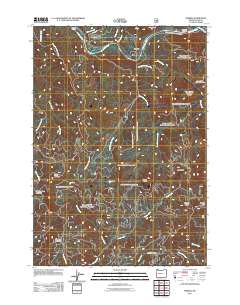
2011 Map of Nimrod
USGS Topo · Published 2011About this map
The McKenzie River winds through the northern portion of this landscape, serving as the primary corridor for settlement and transit near Nimrod. This 2011 survey documents the established riverside landings including Rennie Landing, Silver Creek Landing, and McMullins Landing, which define the water-based access points along the valley floor. To the south, the terrain rises sharply into the Willamette National Forest, where a network of forest roads like NFD 384 Rd and NFD 2611 Rd provides access to high ridges and peaks. Notable elevations such as Pernot Mountain, Gibraltar Mountain, and Nimrod Butte punctuate the landscape, while numerous drainages like Pernot Creek and Hehe Creek feed into the river system. The map reflects a modern balance between small riverfront communities and the managed wilderness of the Cascades foothills.
Find a feature on this map
34 named features on this map. Tap any name to fly to it.
Don’t see what you’re looking for? This feature index may not catch every label — zoom into the map to look around manually.
Map Details
Editions of this 2011 Nimrod Map
This is the sole edition of this map. No revisions or reprints were ever made.
Other maps of this area

1925 · Waldo Lake
USGS Topo · 1:125,000

1934 · Mc Kenzie Bridge
USGS Topo · 1:96,000

1935 · Lowell
USGS Topo · 1:96,000

1940 · Mc Kenzie Bridge
USGS Topo · 1:125,000

1942 · Lowell
USGS Topo · 1:125,000

1951 · Leaburg
USGS Topo · 1:62,500

1953 · Salem
USGS Topo · 1:250,000

1954 · Salem
USGS Topo · 1:250,000

1955 · Hardesty Mtn
USGS Topo · 1:62,500

1955 · Blue River
USGS Topo · 1:62,500