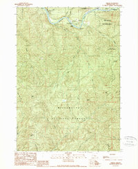
1989 Map of Nimrod
USGS Topo · Published 1989About this map
The McKenzie River carves a central path through this portion of the Willamette National Forest, defining the settlement and recreation patterns of the late 1980s. The small community of Nimrod sits near the river's edge, supported by a network of river access points such as Rennie Landing, Mc Mullins Landing, and Sheppard Landing. These landings, alongside Clover Point County Park and Howard J Morton State Park, underscore the importance of the river for local transit and utility before modern infrastructure dominated the landscape.
Find a feature on this map
35 named features on this map. Tap any name to fly to it.
Don’t see what you’re looking for? This feature index may not catch every label — zoom into the map to look around manually.
Map Details
Editions of this 1989 Nimrod Map
This is the sole edition of this map. No revisions or reprints were ever made.
Other maps of this area

1925 · Waldo Lake
USGS Topo · 1:125,000

1934 · Mc Kenzie Bridge
USGS Topo · 1:96,000

1935 · Lowell
USGS Topo · 1:96,000

1940 · Mc Kenzie Bridge
USGS Topo · 1:125,000

1942 · Lowell
USGS Topo · 1:125,000

1951 · Leaburg
USGS Topo · 1:62,500

1953 · Salem
USGS Topo · 1:250,000

1954 · Salem
USGS Topo · 1:250,000

1955 · Hardesty Mtn
USGS Topo · 1:62,500

1955 · Blue River
USGS Topo · 1:62,500