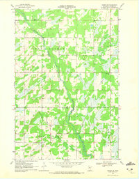
1969 Map of Nimrod SW
USGS Topo · Published 1972About this map
The Redeye River meanders through this portion of Wadena County, defining a landscape of wetlands and small agricultural clearings. The 1969 topography reveals a rural township structure organized into North Germany, Lyons, Wing River, and Bullard districts. These divisions are anchored by local community markers such as North Germany Cem and School No 2422, reflecting the era's decentralized educational and social hubs.
Find a feature on this map
12 named features on this map. Tap any name to fly to it.
Don’t see what you’re looking for? This feature index may not catch every label — zoom into the map to look around manually.
Map Details
Editions of this 1969 Nimrod SW Map
2 editions found
Other maps of this area

1953 · Brainerd
USGS Topo · 1:250,000

1957 · Brainerd
USGS Topo · 1:250,000

1958 · Brainerd
USGS Topo · 1:250,000

1965 · Brainerd
USGS Topo · 1:250,000

1966 · Staples NE
USGS Topo · 1:24,000

1966 · Aldrich North
USGS Topo · 1:24,000

1969 · Sebeka
USGS Topo · 1:24,000

1969 · Verndale
USGS Topo · 1:24,000
1969 · Blue Grass
USGS Topo · 1:24,000
1969 · Nimrod
USGS Topo · 1:24,000