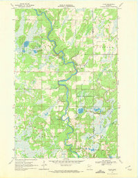
1969 Map of Oylen
USGS Topo · Published 1972About this map
The Crow Wing River winds through this central Minnesota landscape, defining the character of the border between Wadena and Cass counties in the late 1960s. The area is heavily marked by conservation and recreation, including the expansive Lyons State Forest and the Strike Lake State Wildlife Management Area. Cultural history is evident near the river's northern bends, where Indian Mounds are located in close proximity to the Lyons Cem. The small settlement of Oylen serves as a local hub amidst a patchwork of wetlands and timber. This survey illustrates a period of public land management, with dedicated spaces like the Dry Sand Lake State Wildlife Management Area and riparian amenities such as Little Round Hill Campground and Knob Hill Campground providing access to the river's edge and its numerous tributaries, including Beaver Creek and Farnham Creek.
Find a feature on this map
26 named features on this map. Tap any name to fly to it.
Don’t see what you’re looking for? This feature index may not catch every label — zoom into the map to look around manually.
Map Details
Editions of this 1969 Oylen Map
This is the sole edition of this map. No revisions or reprints were ever made.
Other maps of this area

1919 · Leader
USGS Topo · 1:62,500

1953 · Brainerd
USGS Topo · 1:250,000

1957 · Brainerd
USGS Topo · 1:250,000

1958 · Brainerd
USGS Topo · 1:250,000

1965 · Brainerd
USGS Topo · 1:250,000

1966 · Staples NE
USGS Topo · 1:24,000
1966 · Motley NW
USGS Topo · 1:24,000

1966 · Aldrich North
USGS Topo · 1:24,000
1969 · Nimrod SW
USGS Topo · 1:24,000
1969 · Nimrod
USGS Topo · 1:24,000