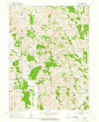
1963 Map of Nind
USGS Topo · Published 1965About this map
Nind sits at the heart of this rural Missouri landscape, where the borders of Sullivan, Adair, Macon, and Linn counties converge. Surveyed in the early 1960s, the map reveals a traditional Midwestern agricultural pattern defined by a network of drainage ways and township lines. The winding path of Mussel Fork and its tributary Little Mussel Creek dominate the southwestern portion, while Walnut Creek flows through the northeast. For those researching local family history, the map preserves the exact locations of civic centers like Willow Branch Sch and College Mound Sch, alongside several rural burial grounds. The presence of Mt Carmel Ch and family-named cemeteries such as Hall Cem and Cheeseman Cem indicates the centers of community life in this quiet corner of the state before modern consolidation changed the rural landscape.
Find a feature on this map
16 named features on this map. Tap any name to fly to it.
Don’t see what you’re looking for? This feature index may not catch every label — zoom into the map to look around manually.
Map Details
Editions of this 1963 Nind Map
This is the sole edition of this map. No revisions or reprints were ever made.
Other maps of this area

1937 · Elmer
USGS Topo · 1:48,000

1938 · Kirksville
USGS Topo · 1:62,500

1940 · Kirksville
USGS Topo · 1:62,500

1942 · Elmer
USGS Topo · 1:62,500

1949 · Bucklin NW
USGS Topo · 1:24,000

1950 · Bucklin NW
USGS Topo · 1:24,000

1951 · New Boston
USGS Topo · 1:24,000

1953 · Moberly
USGS Topo · 1:250,000

1954 · Centerville
USGS Topo · 1:250,000

1954 · Moberly
USGS Topo · 1:250,000