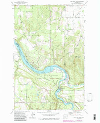
1973 Map of Nine Mile Falls
USGS Topo · Published 1986About this map
Riverside State Park dominates the river corridor where the Spokane River meets the Little Spokane River, preserving significant archaeological and frontier history. The presence of the Spokane House Historic Site and the Fort Spokane Historic Site marks this area as a critical early intersection of the fur trade and colonial expansion. In the 1970s, the landscape reflects a mix of recreation and utilities, with the Nine Mile Falls damming the river into the Nine Mile Res Spokane River and the upstream Long Lake. Away from the water, the terrain rises into Pine Bluff and Lookout Mtn, while a network of rural roads like Burnett Road and Wild Rose Road serves the surrounding uplands. The mapping of underwater contours by Washington Water Power Co. provides unique detail on the submerged topography of the river reservoirs.
Find a feature on this map
50 named features on this map. Tap any name to fly to it.
Don’t see what you’re looking for? This feature index may not catch every label — zoom into the map to look around manually.
Map Details
Editions of this 1973 Nine Mile Falls Map
2 editions found
Other maps of this area

1901 · Spokane
USGS Topo · 1:125,000

1943 · Medical Lake
USGS Topo · 1:62,500

1944 · Clayton
USGS Topo · 1:62,500

1949 · Deer Park
USGS Topo · 1:62,500

1950 · Spokane NW
USGS Topo · 1:24,000

1950 · Spokane
USGS Topo · 1:62,500

1950 · Clayton
USGS Topo · 1:62,500

1951 · Deer Park
USGS Topo · 1:62,500

1954 · Airway Heights
USGS Topo · 1:24,000

1954 · Medical Lake
USGS Topo · 1:62,500