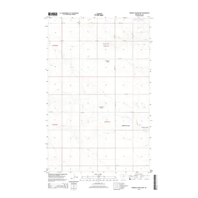
2014 Map of Ninemile Coulee West
USGS Topo · Published 2014About this map
Gildford Colony stands as a focal point of this northern Montana landscape, situated amidst the complex drainage patterns of the high plains. The terrain is defined by several prominent erosional features, including Ninemile Coulee and Tommy Allen Coulee, which carve deep paths through the township boundaries of T36N and T35N. The map illustrates a strictly organized grid of rural transport, where Road 200 N and MT-449 facilitate movement across the open country. This 2014 survey reveals a region where large-scale agricultural settlement and geographical landmarks like Roundup Coulee and Sevenmile Coulee intersect, reflecting the enduring pattern of land use in Hill County.
Find a feature on this map
23 named features on this map. Tap any name to fly to it.
Don’t see what you’re looking for? This feature index may not catch every label — zoom into the map to look around manually.
Map Details
Editions of this 2014 Ninemile Coulee West Map
This is the sole edition of this map. No revisions or reprints were ever made.
Other maps of this area

1906 · Kremlin
USGS Topo · 1:62,500

1920 · Gildford
USGS Topo · 1:125,000

1943 · Gildford
USGS Topo · 1:125,000

1954 · Shelby
USGS Topo · 1:250,000

1958 · Shelby
USGS Topo · 1:250,000

1969 · Gildford NE
USGS Topo · 1:24,000

1969 · Gildford NW
USGS Topo · 1:24,000
1969 · Dry Lake
USGS Topo · 1:24,000
1972 · Lost River NE
USGS Topo · 1:24,000

1972 · Mc Kinnsey Reservoir East
USGS Topo · 1:24,000