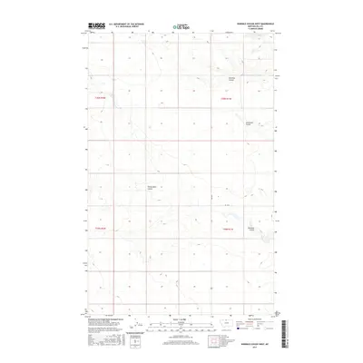
2017 Map of Ninemile Coulee West
USGS Topo · Published 2017About this map
Ninemile Coulee and its neighboring drainage systems define the geography of this North Central Montana landscape. The terrain is characterized by these distinct erosion features, including Roundup Coulee and Sevenmile Coulee, which cut through the high plains. The presence of Tommy Allen Coulee suggests the local history of land ownership or use by early ranching families in Hill County. Human activity in this rural stretch is largely defined by the Public Land Survey System grid, which dictates the layout of local infrastructure like Rd 160 N. This 2017 survey reflects the persistent agricultural and open-range character of the region, where wide-scale ranching operations are organized around the natural contours and occasional water sources provided by these named coulees.
Find a feature on this map
9 named features on this map. Tap any name to fly to it.
Don’t see what you’re looking for? This feature index may not catch every label — zoom into the map to look around manually.
Map Details
Editions of this 2017 Ninemile Coulee West Map
This is the sole edition of this map. No revisions or reprints were ever made.
Other maps of this area

1906 · Kremlin
USGS Topo · 1:62,500

1920 · Gildford
USGS Topo · 1:125,000

1943 · Gildford
USGS Topo · 1:125,000

1954 · Shelby
USGS Topo · 1:250,000

1958 · Shelby
USGS Topo · 1:250,000

1969 · Gildford NE
USGS Topo · 1:24,000

1969 · Gildford NW
USGS Topo · 1:24,000
1969 · Dry Lake
USGS Topo · 1:24,000
1972 · Lost River NE
USGS Topo · 1:24,000

1972 · Mc Kinnsey Reservoir East
USGS Topo · 1:24,000