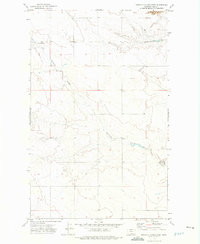
1972 Map of Ninemile Coulee West
USGS Topo · Published 1975About this map
Ninemile Coulee carves through the central terrain of this Hill County landscape, defining the local drainage patterns across the northern High Plains during the early 1970s. The region is characterized by an open, low-density settlement pattern typical of Montana's ranching and agricultural country. A solitary Landing Strip in the northwest corner highlights the importance of aviation for travel and transport in this expansive environment. Along the eastern edge of the survey, a notation for Wild Horse Trail 13 Mi. marks a significant historical route, indicating the orientation of travel toward local hubs. The map reveals the precise township and range boundaries that organized the land into its characteristic grid, providing an essential record for land-use researchers and genealogists tracing family property in the T. 36 N. and T. 35 N. area.
Find a feature on this map
5 named features on this map. Tap any name to fly to it.
Don’t see what you’re looking for? This feature index may not catch every label — zoom into the map to look around manually.
Map Details
Editions of this 1972 Ninemile Coulee West Map
This is the sole edition of this map. No revisions or reprints were ever made.
Other maps of this area

1906 · Kremlin
USGS Topo · 1:62,500

1920 · Gildford
USGS Topo · 1:125,000

1943 · Gildford
USGS Topo · 1:125,000

1954 · Shelby
USGS Topo · 1:250,000

1958 · Shelby
USGS Topo · 1:250,000

1969 · Gildford NE
USGS Topo · 1:24,000

1969 · Gildford NW
USGS Topo · 1:24,000
1969 · Dry Lake
USGS Topo · 1:24,000
1972 · Lost River NE
USGS Topo · 1:24,000

1972 · Mc Kinnsey Reservoir East
USGS Topo · 1:24,000