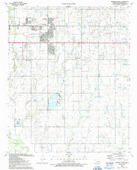
1991 Map of Ninemile Creek
USGS Topo · Published 1991About this map
Residential growth and public infrastructure define the landscape along the Lawton Corporate Boundary at the start of the 1990s. The suburban expansion of eastern Lawton is evident in developments like Carriage Hills and Sullivan Village, supported by an array of educational institutions including Douglas MacArthur High Sch and Park Lane Sch. Beyond the residential clusters, the land transitions into an industrial and utility corridor, featuring a Powerplant and various Oil Wells scattered across the plains.
Find a feature on this map
36 named features on this map. Tap any name to fly to it.
Don’t see what you’re looking for? This feature index may not catch every label — zoom into the map to look around manually.
Map Details
Editions of this 1991 Ninemile Creek Map
This is the sole edition of this map. No revisions or reprints were ever made.
Other maps of this area

1946 · Lawton
USGS Topo · 1:62,500

1949 · Arbuckle Hill
USGS Topo · 1:24,000

1949 · Fort Sill
USGS Topo · 1:24,000

1949 · Nellie
USGS Topo · 1:62,500

1955 · Lawton
USGS Topo · 1:250,000

1956 · Sterling
USGS Topo · 1:24,000

1956 · Ninemile Creek
USGS Topo · 1:24,000

1956 · Arbuckle Hill
USGS Topo · 1:24,000
1956 · Fort Sill
USGS Topo · 1:24,000

1956 · Lawton
USGS Topo · 1:24,000