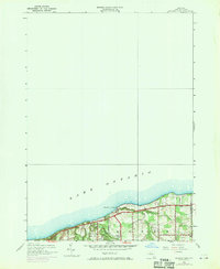
1952 Map of Ninemile Point
USGS Topo · Published 1970About this map
Lake Ontario defines the northern edge of this coastal survey, where the prominent landmark of Ninemile Point juts into the water. In the early 1950s, the area reflects a transition from rural homesteads to suburban growth, particularly near the settlement of Webster. The landscape is etched with a network of long-established thoroughfares such as Lake Road, Whiting Road, and Salt Road, which serve the local community and recreational areas like Webster Beach County Park. This edition includes 1969 revisions shown in purple, highlighting the rapid post-war expansion of urban areas across the Webster township. Traces of an earlier era remain visible in the placement of School No 18 and the Union Cem, providing a look at the civic and social foundations of the county before the modern development boom took hold.
Find a feature on this map
21 named features on this map. Tap any name to fly to it.
Don’t see what you’re looking for? This feature index may not catch every label — zoom into the map to look around manually.
Map Details
Editions of this 1952 Ninemile Point Map
3 editions found
Other maps of this area

1895 · Rochester
USGS Topo · 1:62,500

1895 · Ontario Beach
USGS Topo · 1:62,500

1898 · Rochester
USGS Topo · 1:62,500

1899 · Ontario Beach
USGS Topo · 1:62,500

1900 · Macedon
USGS Topo · 1:62,500

1912 · Rochester
USGS Topo · 1:62,500

1912 · Ontario Beach
USGS Topo · 1:62,500

1920 · Rochester
USGS Topo · 1:62,500

1931 · Rochester East
USGS Topo · 1:24,000

1932 · Webster
USGS Topo · 1:24,000