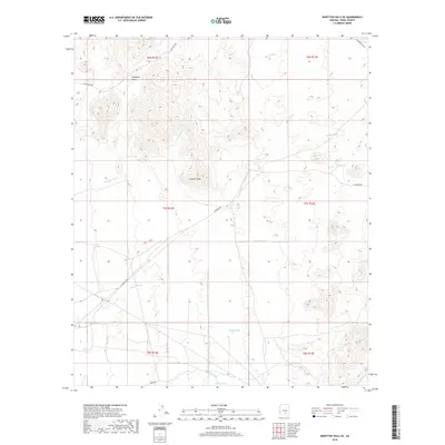
2018 Map of Ninetysix Hills SE
USGS Topo · Published 2018About this map
The Ninetysix Hills dominate this high-desert landscape in Pinal County, where drainage patterns define the geography of the Sonoran scrubland. Prominent seasonal watercourses such as Brady Wash and Tom Mix Wash cut through the terrain, directed toward the lowlands by significant elevations like Coyote Peak. For those researching land use or local history, the map documents a network of vital ranching infrastructure, including Buck Tank, Middle Tank, and South Tank, which provided essential water in this arid environment. The presence of routes like E 96 Ranch Rd and E Freeman Rd indicates the sparse but deliberate connectivity of the region. This 2018 survey detail provides an exact record of natural landmarks and resource points across the township boundaries of T7S and T8S, preserving the nomenclature of the desert washes and peaks as they were recognized in the early 21st century.
Find a feature on this map
21 named features on this map. Tap any name to fly to it.
Don’t see what you’re looking for? This feature index may not catch every label — zoom into the map to look around manually.
Map Details
Editions of this 2018 Ninetysix Hills SE Map
This is the sole edition of this map. No revisions or reprints were ever made.
Other maps of this area

1911 · Winkelman
USGS Topo · 1:125,000

1913 · Winkelman
USGS Topo · 1:125,000

1934 · Newman Peak
USGS Topo · 1:125,000

1949 · Crozier Peak
USGS Topo · 1:24,000

1949 · Winkelman
USGS Topo · 1:62,500

1949 · Black Mountain
USGS Topo · 1:24,000
1950 · Crozier Peak
USGS Topo · 1:24,000
1950 · Black Mountain
USGS Topo · 1:24,000
1951 · Winkelman
USGS Topo · 1:62,500

1956 · Tucson
USGS Topo · 1:250,000