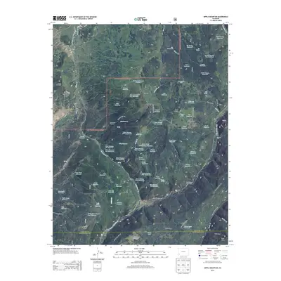
2013 Map of Nipple Mountain
USGS Topo · Published 2013About this map
San Juan National Forest defines the high-country landscape of the Colorado Rockies in this 2013 survey, where water management and ranching intersect. The map detail centers on Nipple Mountain and the extensive plateau of Stoner Mesa, providing a look at the numerous man-made water features required for land use in this terrain, including Big Reservoir, Lila Reservoir, and Quakie Reservoir. The West Dolores River cuts through the southeastern corner, supported by several recreation sites such as West Dolores Campground and Mavreeso Campground. Land use is further illustrated by the presence of King Ranch and various cattle-related infrastructure labels. Topographically, the map traces the dramatic drop from Taylor Mesa into the deep cut of Mavreeso Canyon, while naming several family-associated landmarks like Hugh Ray Flats and McEwen Reservoir.
Find a feature on this map
81 named features on this map. Tap any name to fly to it.
Don’t see what you’re looking for? This feature index may not catch every label — zoom into the map to look around manually.
Map Details
Editions of this 2013 Nipple Mountain Map
This is the sole edition of this map. No revisions or reprints were ever made.
Other maps of this area

1897 · Rico
USGS Topo · 1:62,500

1898 · Rico
USGS Topo · 1:62,500

1899 · Rico
USGS Topo · 1:62,500

1956 · Cortez
USGS Topo · 1:250,000

1958 · Cortez
USGS Topo · 1:250,000

1959 · Cortez
USGS Topo · 1:250,000

1962 · Cortez
USGS Topo · 1:250,000

1963 · Stoner
USGS Topo · 1:24,000
1963 · Wallace Ranch
USGS Topo · 1:24,000
1963 · Nipple Mountain
USGS Topo · 1:24,000