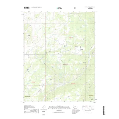
2019 Map of Nipple Mountain
USGS Topo · Published 2019About this map
The high-elevation terrain of San Juan National Forest defines this part of the Colorado landscape, where the West Dolores River carves through the eastern portion of the quadrangle. Significant peaks like Nipple Mtn and Beaver Mtn rise above a complex network of canyons and draws, including Mavreeso Canyon and Rocky Draw. This 2019 survey reveals a modern emphasis on water management across the high plateau, documented by dozens of named reservoirs such as Big Reservoir, Lila Reservoir, and the Zwicker Reservoir system. These catchments, alongside landmarks like Hugh Ray Flats and Stoner Mesa, suggest a landscape utilized for seasonal grazing and resource management. Transportation is limited to rugged routes like the Ground Hog Cutoff and the Cottonwood Connector, reflecting the area's isolation along the Dolores and Montezuma County border.
Find a feature on this map
67 named features on this map. Tap any name to fly to it.
Don’t see what you’re looking for? This feature index may not catch every label — zoom into the map to look around manually.
Map Details
Editions of this 2019 Nipple Mountain Map
This is the sole edition of this map. No revisions or reprints were ever made.
Other maps of this area

1897 · Rico
USGS Topo · 1:62,500

1898 · Rico
USGS Topo · 1:62,500

1899 · Rico
USGS Topo · 1:62,500

1956 · Cortez
USGS Topo · 1:250,000

1958 · Cortez
USGS Topo · 1:250,000

1959 · Cortez
USGS Topo · 1:250,000

1962 · Cortez
USGS Topo · 1:250,000

1963 · Stoner
USGS Topo · 1:24,000
1963 · Wallace Ranch
USGS Topo · 1:24,000
1963 · Nipple Mountain
USGS Topo · 1:24,000