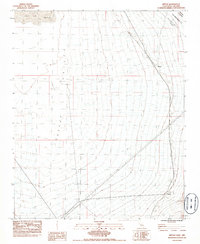
1983 Map of Nipton
USGS Topo · Published 1983About this map
Nipton serves as a lonely outpost along the Union Pacific tracks in this high desert landscape during the early 1980s. The map illustrates a harsh, arid environment dominated by the expansive Ivanpah Valley and the dry bed of Ivanpah Lake. Historical political boundaries are a defining characteristic here, specifically the Von Schmidt Line (1873) (Approx) marking the border between San Bernardino Co and Nevada. Water sources are scarce but critical to the area's utility, marked by features such as Mesquite Holes and Murphy Well. This provisional survey records the stark geography of the Mojave Desert at a time when rail transport remained the primary link between these remote settlements and the outside world.
Find a feature on this map
9 named features on this map. Tap any name to fly to it.
Don’t see what you’re looking for? This feature index may not catch every label — zoom into the map to look around manually.
Map Details
Editions of this 1983 Nipton Map
2 editions found
Other maps of this area

1910 · Ivanpah
USGS Topo · 1:250,000

1912 · Ivanpah
USGS Topo · 1:250,000

1942 · Ivanpah
USGS Topo · 1:250,000

1947 · Kingman
USGS Topo · 1:250,000

1948 · Kingman
USGS Topo · 1:250,000

1954 · Kingman
USGS Topo · 1:250,000

1955 · Kingman
USGS Topo · 1:250,000

1955 · Roach Lake
USGS Topo · 1:62,500

1956 · Ivanpah
USGS Topo · 1:62,500
1956 · Crescent Peak
USGS Topo · 1:62,500