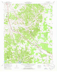
1976 Map of Noah
USGS Topo · Published 1978About this map
The rolling hills of the Bedford and Coffee County border define this mid-1970s Tennessee landscape, where the Dixie Highway and Highway 41 cut through a countryside dotted with small family burial grounds and community landmarks. The settlement of Noah serves as a central point for the region, surrounded by numerous hollows like Huffman Hollow and Norvell Hollow. Further south, the landscape transitions into the distinctive terrain of The Barrens near Fredonia.
Find a feature on this map
84 named features on this map. Tap any name to fly to it.
Don’t see what you’re looking for? This feature index may not catch every label — zoom into the map to look around manually.
Map Details
Editions of this 1976 Noah Map
This is the sole edition of this map. No revisions or reprints were ever made.
Other maps of this area

1913 · Hollow Springs
USGS Topo · 1:62,500

1936 · Ovoca
USGS Topo · 1:24,000

1936 · Webbs Jungle
USGS Topo · 1:24,000

1936 · Fredonia
USGS Topo · 1:24,000

1936 · Manchester
USGS Topo · 1:24,000

1936 · Beech Grove
USGS Topo · 1:24,000

1936 · Petty Gap
USGS Topo · 1:24,000

1936 · Noah
USGS Topo · 1:24,000

1936 · Wartrace
USGS Topo · 1:24,000

1936 · Normandy
USGS Topo · 1:24,000