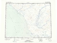
1951 Map of Noatak
USGS Topo · Published 1955About this map
Kivalina and Noatak stand as the primary coastal and inland hubs in this 1951 reconnaissance mapping of the Northwest Arctic. This survey captures a region defined by its expansive river systems, where the Noatak River and Agashashok River wind through the Igichuk Hills toward the Kotzebue Sound. The map documents the vital infrastructure of the era, including a noted airstrip and a Winter Trail following the shoreline from Cape Seppings past Corwin Lagoon.
Find a feature on this map
21 named features on this map. Tap any name to fly to it.
Don’t see what you’re looking for? This feature index may not catch every label — zoom into the map to look around manually.
Map Details
Editions of this 1951 Noatak Map
2 editions found
Other maps of this area

1950 · Shishmaref
USGS Topo · 1:250,000

1951 · De Long Mountains
USGS Topo · 1:250,000

1951 · Baird Mountains
USGS Topo · 1:250,000

1951 · Selawik
USGS Topo · 1:250,000

1951 · Shishmaref
USGS Topo · 1:250,000

1951 · Noatak
USGS Topo · 1:250,000

1951 · Kotzebue
USGS Topo · 1:250,000

1951 · Misheguk Mountain
USGS Topo · 1:250,000

1951 · Kotzebue D-1
USGS Topo · 1:63,360

1951 · Kotzebue D-2
USGS Topo · 1:63,360