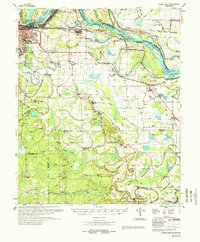
1978 Map of Noble Lake
USGS Topo · Published 1978About this map
Arkansas River meanders define the northern boundary of this landscape, where the Brunson Crossing and various revetments mark the river's controlled course. Just south of Pine Bluff, the terrain transitions into a complex network of bayous and old river channels, including the prominent Noble Lake and Atkins Lake. The settlement pattern reflects a deeply rooted rural community, with numerous small congregations such as Stewart Chapel, St Raphaels Ch, and Pilgrims Rest Ch dotting the countryside.
Find a feature on this map
74 named features on this map. Tap any name to fly to it.
Don’t see what you’re looking for? This feature index may not catch every label — zoom into the map to look around manually.
Map Details
Editions of this 1978 Noble Lake Map
This is the sole edition of this map. No revisions or reprints were ever made.
Other maps of this area

1932 · Pastoria
USGS Topo · 1:62,500

1935 · Feenyville
USGS Topo · 1:62,500

1935 · Altheimer
USGS Topo · 1:62,500

1935 · Pastoria
USGS Topo · 1:62,500

1935 · Varner
USGS Topo · 1:62,500

1935 · Noble Lake
USGS Topo · 1:62,500

1935 · Rotan
USGS Topo · 1:62,500

1941 · Goldman
USGS Topo · 1:62,500

1948 · Helena
USGS Topo · 1:250,000

1950 · Helena
USGS Topo · 1:250,000