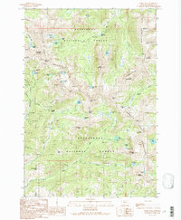
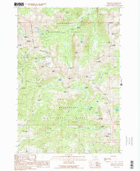
1989 Map of Noble Peak
USGS Topo · Published 1989About this map
The Tobacco Root Mountains dominate this high-altitude landscape where the Deerlodge National Forest and Beaverhead National Forest converge. This 1980s-era topographic record details a region defined by its intensive mining history and dramatic alpine hydrology. Numerous extraction sites, including the Bismark Mine near the Bismark Reservoir and the Noble Mine above Noble Gulch, testify to the area's geological value.
Find a feature on this map
77 named features on this map. Tap any name to fly to it.
Don’t see what you’re looking for? This feature index may not catch every label — zoom into the map to look around manually.
Map Details
Editions of this 1989 Noble Peak Map
2 editions found
Other maps of this area

1888 · Three Forks
USGS Topo · 1:250,000

1893 · Dillon
USGS Topo · 1:250,000

1894 · Three Forks
USGS Topo · 1:250,000

1895 · Three Forks
USGS Topo · 1:250,000

1947 · Bozeman
USGS Topo · 1:250,000

1948 · Bozeman
USGS Topo · 1:250,000
1950 · Harrison
USGS Topo · 1:62,500
1950 · Virginia City
USGS Topo · 1:62,500

1955 · Bozeman
USGS Topo · 1:250,000

1955 · Dillon
USGS Topo · 1:250,000