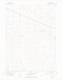
1978 Map of Node
USGS Topo · Published 1978About this map
Node serves as the central hub of this eastern Wyoming landscape, situated along the Chicago and North Western railroad line. The settlement's infrastructure is tightly coupled with the rail corridor, which cuts diagonally across the high plains. Water sources like Duck Creek, Silver Springs Creek, and the Niobrara River define the local drainage patterns, while the distinctive Chimney Rock stands as a prominent natural landmark in the southern reaches of the quadrangle. Outside the immediate vicinity of the town and its local Cem, the map reveals a sparsely populated ranching environment marked by an extensive Pipeline network and numerous wells, reflecting the region's 1970s land use and resource management. The grid of section lines and fence markers provides a clear view of the rural property divisions that have long shaped Niobrara County.
Find a feature on this map
8 named features on this map. Tap any name to fly to it.
Don’t see what you’re looking for? This feature index may not catch every label — zoom into the map to look around manually.
Map Details
Editions of this 1978 Node Map
This is the sole edition of this map. No revisions or reprints were ever made.
Other maps of this area

1954 · Torrington
USGS Topo · 1:250,000

1958 · Torrington
USGS Topo · 1:250,000

1974 · Mc Master Reservoir
USGS Topo · 1:24,000

1974 · Rawhide Buttes East
USGS Topo · 1:24,000
1974 · Reynolds Spring
USGS Topo · 1:24,000

1977 · Hileman Draw
USGS Topo · 1:24,000

1977 · Prairie Center
USGS Topo · 1:24,000

1978 · Kirtley SW
USGS Topo · 1:24,000

1981 · Lusk
USGS Topo · 1:24,000
1981 · Signature Rock
USGS Topo · 1:24,000