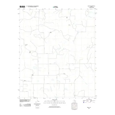
2010 Map of Nolan
USGS Topo · Published 2010About this map
The small community of Nolan serves as the focal point for this rural landscape in the southern part of Nolan County, where the plains meet distinct geological breaks. High points such as Black Point, Ringtop, and the prominent Birdsnest Bluff define the horizon, while the drainage network is carved by Mulberry Creek and Weaver Springs Creek. The agricultural and ranching heritage of the area is evident in the dense grid of county roads, including Co RD 208 and Co RD 196, which connect isolated homesteads and local landmarks. Genealogists will find significant value in the documentation of early burial sites like Slater Chapel Cemetery and Dora Cemetery. The terrain is further characterized by local natural features like Coffee Hollow and Indian Hand Bluff, illustrating the intersection of the region's rugged geography with long-established Texas cattle and farming traditions.
Find a feature on this map
28 named features on this map. Tap any name to fly to it.
Don’t see what you’re looking for? This feature index may not catch every label — zoom into the map to look around manually.
Map Details
Editions of this 2010 Nolan Map
This is the sole edition of this map. No revisions or reprints were ever made.
Other maps of this area

1893 · Sweetwater
USGS Topo · 1:125,000

1954 · Big Spring
USGS Topo · 1:250,000

1957 · Merkel
USGS Topo · 1:62,500

1958 · Big Spring
USGS Topo · 1:250,000
1967 · Shep
USGS Topo · 1:24,000

1967 · Hylton
USGS Topo · 1:24,000

1969 · Blackwell NE
USGS Topo · 1:24,000

1969 · Holder Creek
USGS Topo · 1:24,000
1969 · Lake Sweetwater
USGS Topo · 1:24,000
1984 · Merkel West
USGS Topo · 1:24,000