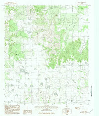
1984 Map of Nolan
USGS Topo · Published 1984About this map
Nolan sits at the base of a complex escarpment in the mid-1980s, where the high mesas of the Rolling Plains begin to break toward the Canyon country to the east. This provisional survey documents a landscape defined by significant elevation changes, prominently marked by landmarks such as Indian Hand Bluff and Birdsnest Bluff. The drainage pattern is intricate, with the North Fork Elm Creek and Valley Creek carving through the terrain alongside Mulberry Creek. Local history is anchored by the community Cemetery and the small settlement at Nolan, while the surrounding area shows signs of rural utility with a prominent Radio Tower and various springs. The boundary between Nolan Co and Taylor Co runs through the eastern portion of the sheet, dividing a landscape of deep hollows like Coffee Hollow from the high points of Ringtop and Black Point.
Find a feature on this map
19 named features on this map. Tap any name to fly to it.
Don’t see what you’re looking for? This feature index may not catch every label — zoom into the map to look around manually.
Map Details
Editions of this 1984 Nolan Map
This is the sole edition of this map. No revisions or reprints were ever made.
Other maps of this area

1893 · Sweetwater
USGS Topo · 1:125,000

1954 · Big Spring
USGS Topo · 1:250,000

1957 · Merkel
USGS Topo · 1:62,500

1958 · Big Spring
USGS Topo · 1:250,000
1967 · Shep
USGS Topo · 1:24,000

1967 · Hylton
USGS Topo · 1:24,000

1969 · Blackwell NE
USGS Topo · 1:24,000

1969 · Holder Creek
USGS Topo · 1:24,000
1969 · Lake Sweetwater
USGS Topo · 1:24,000
1984 · Merkel West
USGS Topo · 1:24,000