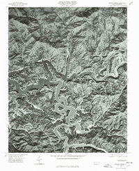
1976 Map of Noland Creek
USGS Topo · Published 1978About this map
Fontana Lake dominates this mid-1970s orthophoto, where the winding arms of the reservoir fill the deep mountain valleys of the Great Smoky Mountains. The intricate shoreline reveals the complex geography formed as the waters of the Little Tennessee River and the Tuckasegee River were impounded, creating a jagged aquatic landscape that contrasts sharply with the densely forested ridges. High-elevation terrain features like Jackson Line Mountain and the distinct peak of Roundhill overlook the submerged riverbeds. The aerial imagery captures the drainage patterns of Forney Creek and Noland Creek as they feed into the northern reaches of the lake. This visual survey provides a clear view of the wilderness character and hydrological state of the region before further development or ecological shifts in the late 20th century.
Find a feature on this map
7 named features on this map. Tap any name to fly to it.
Don’t see what you’re looking for? This feature index may not catch every label — zoom into the map to look around manually.
Map Details
Editions of this 1976 Noland Creek Map
This is the sole edition of this map. No revisions or reprints were ever made.
Other maps of this area

1886 · Knoxville
USGS Topo · 1:125,000

1891 · Cowee
USGS Topo · 1:125,000

1892 · Knoxville
USGS Topo · 1:125,000

1893 · Mt Guyot
USGS Topo · 1:125,000

1894 · Knoxville
USGS Topo · 1:125,000

1895 · Knoxville
USGS Topo · 1:125,000

1897 · Cowee
USGS Topo · 1:125,000

1901 · Knoxville
USGS Topo · 1:125,000

1907 · Cowee
USGS Topo · 1:125,000

1912 · Mt Guyot
USGS Topo · 1:125,000