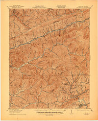
1919 Map of Nolansburg
USGS Topo · Published 1945About this map
Pine Mountain and Cumberland Mountain dominate this corner of the Appalachian coalfields, where the steep terrain dictated a pattern of narrow valley settlements along the Poor Fork and Clover Fork. The map records the industrial landscape of Harlan County during the height of the early 20th-century mining boom, showing the critical role of the Louisville & Nashville RR and the Southern Ry in connecting isolated communities like Evarts and Nolansburg to the outside world. Cultural and educational life is anchored by the Pine Mountain Settlement School, a notable institution established to serve the rural mountain population. Further south near the Virginia border, mining activity and post offices such as Imperial and Leona Mines PO appear alongside Pennington Gap, illustrating the cross-border economic ties through the Pocket and over the mountain gaps.
Find a feature on this map
64 named features on this map. Tap any name to fly to it.
Don’t see what you’re looking for? This feature index may not catch every label — zoom into the map to look around manually.
Map Details
Editions of this 1919 Nolansburg Map
3 editions found

Other maps of this area

1887 · Jonesville
USGS Topo · 1:125,000

1890 · Whitesburg
USGS Topo · 1:125,000

1891 · Hazard
USGS Topo · 1:125,000

1891 · Jonesville
USGS Topo · 1:125,000

1892 · Whitesburg
USGS Topo · 1:125,000

1894 · Estillville
USGS Topo · 1:125,000

1903 · Harlan
USGS Topo · 1:48,000

1913 · Oven Fork
USGS Topo · 1:48,000

1915 · Whitesburg
USGS Topo · 1:62,500

1916 · Cornettsville
USGS Topo · 1:62,500