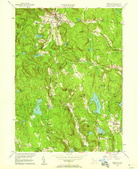
1956 Map of Norfolk
USGS Topo · Published 1958About this map
Norfolk sits at the northern edge of this Litchfield County landscape, where the Blackberry River cuts through the high ground of Canaan Mtn. The 1956 topography reveals a region defined by its diverse water bodies and conserved lands, including the recreation grounds of Haystack Mtn State Park and Dennis Hill State Park. Significant local history is preserved in the location of rural hamlets like South Norfolk and Grantville, alongside numerous family and community burial grounds such as Hall Meadow Cem and Danbury Quarter Cem. The southern reach of the map shows the transition toward Torrington, marked by the Reuben Hart Reservoir and the Naugatuck River headwaters. Notable for genealogists, the Winchester Center PO and small intersections like Kelly Corner provide specific anchors for mid-century settlement patterns in the Connecticut highlands.
Find a feature on this map
77 named features on this map. Tap any name to fly to it.
Don’t see what you’re looking for? This feature index may not catch every label — zoom into the map to look around manually.
Map Details
Editions of this 1956 Norfolk Map
4 editions found
Other maps of this area

1885 · Sheffield
USGS Topo · 1:62,500

1888 · Sheffield
USGS Topo · 1:62,500

1888 · Sandisfield
USGS Topo · 1:62,500

1891 · Sheffield
USGS Topo · 1:62,500

1892 · Winsted
USGS Topo · 1:62,500

1892 · Cornwall
USGS Topo · 1:62,500

1893 · Sheffield
USGS Topo · 1:62,500

1893 · Cornwall
USGS Topo · 1:62,500

1893 · Sandisfield
USGS Topo · 1:62,500

1897 · Sandisfield
USGS Topo · 1:62,500