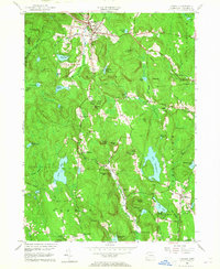
1956 Map of Norfolk
USGS Topo · Published 1965About this map
Norfolk sits as a central hub in this mid-century portrait of Litchfield County, where the southern reaches of the Berkshires create a landscape defined by significant elevation changes and numerous water bodies. The terrain is anchored by peaks like Dutton Mtn and Canaan MTN, while the Mad River and Blackberry River carve paths through the highlands. To the south and east, the transition from forest to settlement is marked by clusters of local history, including Winchester Center PO and the scattered homes of North Goshen.
Find a feature on this map
72 named features on this map. Tap any name to fly to it.
Don’t see what you’re looking for? This feature index may not catch every label — zoom into the map to look around manually.
Map Details
Editions of this 1956 Norfolk Map
4 editions found
Other maps of this area

1885 · Sheffield
USGS Topo · 1:62,500

1888 · Sheffield
USGS Topo · 1:62,500

1888 · Sandisfield
USGS Topo · 1:62,500

1891 · Sheffield
USGS Topo · 1:62,500

1892 · Winsted
USGS Topo · 1:62,500

1892 · Cornwall
USGS Topo · 1:62,500

1893 · Sheffield
USGS Topo · 1:62,500

1893 · Cornwall
USGS Topo · 1:62,500

1893 · Sandisfield
USGS Topo · 1:62,500

1897 · Sandisfield
USGS Topo · 1:62,500