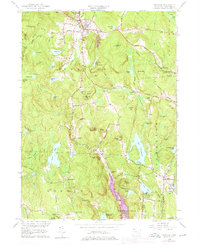
1956 Map of Norfolk
USGS Topo · Published 1976About this map
Norfolk serves as a prominent focal point in this upland Litchfield County landscape, situated where the Blackberry River winds through a terrain defined by high summits like Canaan Mtn and Dennis Hill. The settlement pattern follows the narrow valleys and ridges of the southern Berkshires, with smaller hubs such as South Norfolk and Winchester Center PO providing a look at the mid-century rural infrastructure. This 1969 photorevised edition highlights the area's conservation legacy, showing the established footprints of Haystack Mtn State Park and Dennis Hill State Park.
Find a feature on this map
71 named features on this map. Tap any name to fly to it.
Don’t see what you’re looking for? This feature index may not catch every label — zoom into the map to look around manually.
Map Details
Editions of this 1956 Norfolk Map
4 editions found
Other maps of this area

1885 · Sheffield
USGS Topo · 1:62,500

1888 · Sheffield
USGS Topo · 1:62,500

1888 · Sandisfield
USGS Topo · 1:62,500

1891 · Sheffield
USGS Topo · 1:62,500

1892 · Winsted
USGS Topo · 1:62,500

1892 · Cornwall
USGS Topo · 1:62,500

1893 · Sheffield
USGS Topo · 1:62,500

1893 · Cornwall
USGS Topo · 1:62,500

1893 · Sandisfield
USGS Topo · 1:62,500

1897 · Sandisfield
USGS Topo · 1:62,500